Showing posts with label "Bianchi Lupo". Show all posts

view the broad map with a meters above the sea level graph


I joined M who cycled from Machida in Fuchinobe, and we cycled to Doshi together. I have talked with him on the phone, but it was the first time that I meet. He said , "I'm a beginner and cannot cycle very much", but he was an impostor. He went up a steep slope of 12% with nonchalance.
Besides, he glares around with a grim cycle-wear.
On his back was written "輪" with a writing brush.

We rode chrome molybdenum steel bikes made by Bianchi.

The Doshi River is quiet and feel peace within my mind.
It will be a half month more to colored leaves.

100.36Km

The Kohbu-tunnel

Oct 27, 2011

view the broad map with a meters above the sea level graph

The Kohbu-tunnel links Tokyo to Yamanashi.
Yamanashi was called Kohshu in the Edo era. Tokyo was called Musashi in the Edo era. Therefore it was named Kobu-tunnel. It was completed 20 years ago, not during the Edo era.

I turned right onto a mountain road from national highway 20. There was a fire watchtower which was removed from the city.

Because the tunnel was new and well-lit, I was able to pedal safely by bike.

When I passed through the tunnel, a thrilling downhill slope spread out.

I came back along the Akikawa River and the Tama River.

133.48km

view the broad map with a meters above the sea level graph

I wanted to cycle along a mountain course when I watched the Tour de France. Because the Alps are 10,000 km distant, I cycled through Tanzawa in Kanagawa.
Yabitsu Pass was 761 meters above sea level. I cycled up 660m over 12km from Hadano at the foot of the mountain.
When I went over the mountain pass, I enjoyed a long downhill ride to the Miyagase dam.

This way was suitable for cycling because there were few cars.

Hanbara Pass was 490 meters above sea level. I cycled up 300m over 4.5km.

126.14Km
accumulation elevations 1750m

view the broad map with a meters above the sea level graph

I pedaled in Setagaya, which was a residential area of Tokyo.
Shoin Shrine was a Shinto shrine to honor Shoin Yoshida. After the Meiji Restoration, pupils of Yoshida constructed this shrine. Here were graves of Shoin Yoshida and Mikisaburo Rai, who died from penalty by the Mass Execution of Ansei. The Mass Execution of Ansei was political oppression by chief ministry Naosuke Ii of the Edo Shogunate.

Graves of the Ii's family were in the west, across the Setagaya ward office from Shoin Shrine. Here was a grave of Naosuke Ii. He was killed in the Sakurada-mongai assassination.
These events happened 150 years ago.

32.12Km

view the broad map with a meters above the sea level graph

This place is 3 kilometers of range from the head office of TEPCO.
This place is 200 kilometers away from the Fukushima Nuclear Power Plant of TEPCO.

The National Museum of Modea Art, Tokyo (built in 1910)

Kitanomaru-kouen park, a quiet spring day.
Ushigafuchi moat seen from Tayasu-mon gate.
63.30Km

view the broad map with a meters above the sea level graph
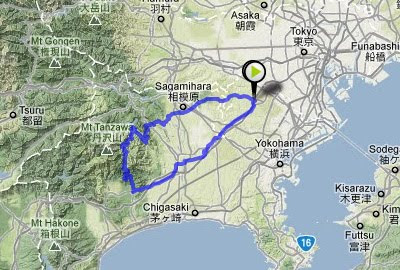
In the days of the Edo era, Japan closed the country, but the U.S. and Russia came to demand the opening of the country from the latter half of the 19th century. The shogun commanded the daimyo throughout the country to build batteries on the shore. A battery was built in Kanagawa facing Yokohama port. Kaishu Katsu designed it. It's called Kanagawa Daiba.
As for the battery, which had been an artificial island, the surrounding area was filled-in and it has been changed to a station and private houses now.
The anchorage became a small park, and there was a detailed sign which commemorated the old days.

50.57Km / 5hours

The distance by road from Shikoku to Tokyo is 800km. I took a ferry because it was slightly too far to go by bicycle.
It's easy when I use the ship because I can carry the bicycle without dismantling it.
As for the fare, it was 10,000 yen per person, 2,800 yen per bicycle, and the travel time was 18 hours.

I waited for the sunrise and started cycling so I arrived at the Tokyo Port before daybreak. I cycled to my house via Ginza, which is the greatest shopping street in Tokyo. Ginza in the early morning was still "sleeping".

view the big map with a meters above the sea level graph

The Great Naruto Bridge, built in 1985, had two layers: a highway and the Shinkansen. However, the government stopped the construction of the Shinkansen, and the first floor was wasted.
A ferry that bicycles could ride ran in the past, but it was discontinued. I cannot cross the straits by bicycle.
To make a bicycle path, in substitution for the Shinkansen, is a wish of the cyclists. It would be an advancement for Japan.

90.74Km / 6hours

view the big map with a meters above the sea level graph

I cycled to Kamiyama-cho to buy bread baked by firewood.
Kamiyama-cho is a depopulated town in the mountains. The municipal government rents out the unoccupied houses at low-cost to revitalize the town. The bakery storekeeper is a couple who moved from Osaka. Because bread is cheap and delicious, they have a good reputation. I bought two pieces of french bread. They are still warm, but will be cold by the time I cycle the 30 kilometers to my house.
Scarecrows decorate the roadside. They are works of art.
The population of the town decreases, but the scarecrows increase.
 
62.5Km / 4hours

A forgotten way

Jan 21, 2011

view the big map with a meters above the sea level graph

The National highway No.11, that links Tokushima to Takamatsu, has changed the route twice. The route that was used until 1953 has been left as a prefectural road. However, the oldest route, which was built in 1875 and used until 1920, is a disused road now.
There was a monument at the starting point of that road. I imagined the time when this place was a trunk line.

The roadbed was made strong and the way was left clear. However, nobody goes now because has been forgotten, and does not appear on any map. When I approached the mountain pass, the road had been covered by bamboo. I got off my bicycle and pushed it.

A bright view opened up when I passed through the shadowy mountain path. It may be 50 years since a person last went this way.
70.56Km / 6hours

Ohkawara Heights

Jan 1, 2011

view the big map with a meters above the sea level graph

I was attracted by the good weather, so I cycled to Ohkawara Heights which was 910m in height. Many cyclists in Tokushima, they usually practices hill climb here.
The temperature was below the freezing point, but became hotter when I began climbing the slope. I took off clothes in sequence, and at last I became only wear a T-shirt only.

In a ridge line of the mountaintop, wind-power generators were lined up. I saw the Great Naruto Bridge where was 50km distant.

66.97km/Total 4h

view the big map with a meters above the sea level graph

This summer, I went to temple No.12: Syosan-ji temple. This part has the steepest slope of the Shikoku pilgrimage.
The distance of uphill slope was 4.5Km and the slant was 10%. The distance was shorter than that of the Syosan-ji temple, but the slant was a bit steeper. I got a backache from cycling on the slant.
The slope became level road when I went up for a ridge line, but it came back to more than 10% for an immediately, and I could not take a break.
Though I am not a Buddhist, I felt I might achieve enlightenment from enduring this struggle!
There was a big temple that had a three-story pagoda built in the Edo era. Because it was the off-season, nobody was there. A strong north wind shook the trees.
58.66km/Total 6h

I was cycling in Yoshino district of Nara which is 100 kilometers south from Kyoto.

Getting a new cycling friend is one of the charms of bicycle touring.
I caught up with a old man who rode a classic bicycle and I talked "Where are you going ?" when riding side by side.
He led me cycling as a local guide.
I saw the monument of revolt of "Tenchugumi", the non-authorized force of the Revering the emperor and expelling the barbarians party.
The Tenchugumi was defeated completely by Shogunate forces in 1863 but this battle became the flash point of Meiji Restoration.

101.81Km /Total 7h


view the big map with a meters above the sea level graph

Because I was going to cross over the mountains today, I wanted to depart early, but decided to participate in a guided early morning worship in the Naiku-Shrine.

Shinto is difficult to understand, like other religions. I thought maybe I could get some idea of what it was about.

God is in the place of nothingness, is not a shrine building

Because I avoided the city and cycled on the old road, neither convenience stores nor the fast food shops were around. I finally found the quiet Ise-noodle dining room. It's said "famous food is generally not good" in Japan. However, the white noodles of this dining room were very delicious. It lived up to its famous name as the Ise-udon.

The upper part: a bad noodle shop in the sightseeing spot. I ate here yesterday.
The lower part: a delicious noodle shop in the country.I ate here today.

99.24Km/Total 10h


Japan Part for LABEL

Japan Part for LABEL

Powered by Lang-8 friends

boso.cycle@gmail.com


Taka
If you want to know the details, write a comment or send an email.

free counters