view the broad map with a meters above the sea level graph

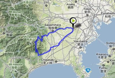
We pedaled in Okutama at the off-line meeting of the folding bike club.
Today was the first tour that I arranged. At 10:00 a.m. , five members gathered at Fujino Station.

We biked across the Tsuru mountain pass which was 870m in height, and rode over to Lake Okutama.

Because it was the holiday, during the height of the colored leaves season, many people were out riding road bikes.

Lake Okutama was at the upper reaches of the Tama River flowing through Tokyo. The railroad station is near, so we'll be there soon.

148.01 km。

view the broad map with a meters above the sea level graph


I joined M who cycled from Machida in Fuchinobe, and we cycled to Doshi together. I have talked with him on the phone, but it was the first time that I meet. He said , "I'm a beginner and cannot cycle very much", but he was an impostor. He went up a steep slope of 12% with nonchalance.
Besides, he glares around with a grim cycle-wear.
On his back was written "輪" with a writing brush.

We rode chrome molybdenum steel bikes made by Bianchi.

The Doshi River is quiet and feel peace within my mind.
It will be a half month more to colored leaves.

100.36Km

The Kohbu-tunnel

Oct 27, 2011

view the broad map with a meters above the sea level graph

The Kohbu-tunnel links Tokyo to Yamanashi.
Yamanashi was called Kohshu in the Edo era. Tokyo was called Musashi in the Edo era. Therefore it was named Kobu-tunnel. It was completed 20 years ago, not during the Edo era.

I turned right onto a mountain road from national highway 20. There was a fire watchtower which was removed from the city.

Because the tunnel was new and well-lit, I was able to pedal safely by bike.

When I passed through the tunnel, a thrilling downhill slope spread out.

I came back along the Akikawa River and the Tama River.

133.48km

Hatsusaburo Yoshida (1884-1955) got to be popular by a bird's-eye view in the early Showa period.
He drew sightseeing maps that were not to scale. I was surprised by this unbelievable map, and I haven't tired of looking at it. Although he followed his field work closely, he included invisible elements in his phantasmagoric conception. He warped perspective, not only space but also time, and drew it in one picture.
His work is still popular.
If I cycle with his map, I'm buried in Tokyo Bay.

view the broad map with a meters above the sea level graph

I pedaled in Kamakura at the off-line meeting of the folding bike club. At 10:00 a.m. , nine members gathered at Kita-Kamakura Station.

The first samurai Administration began in the 12th century in this city.
Because it is an ancient city near Tokyo, so many tourists were visiting there.

Beautiful origami paper cranes were dedicated at Zeniarai-benten.

Komyo-ji in Zaimokuza is the quiet temple which is a little far from the city center, but there is a well groomed garden.

Kamakura has various scenery in the undulating landscape.
I was able to go on cycling the way along the shore which opened out, the mountain path of a deep forest, and lively cityscape, at a time.

 40Km

view the broad map with a meters above the sea level graph

I went down stream on the Akui River with my biking friend by kayak.
We wore life vests, but other than that we had on bike wear. It was a twin-seater kayak like a tandem bike. However, the paddle control is different than the pedal control; the paddle uses not only thrust force. We must synchronize the way of the boat at once.
I recorded a video in a pillion seat. My foot appeared for an instant.

Kudoyama and Koyasan

Aug 26, 2011

view the broad map with a meters above the sea level graph

I stayed in a Japanese hotel in Kudoyama-cho and cycled up to Mt. Koya-san. By chance, the Bon Festival was going on, and I could see farewell bonfires at Sanadaan in Kudoyama.

Kongohbuji temple is on Mt. Koya-san. It rises 750m from the foot of the mountain. This temple is the head temple of Shingon Buddhism.
Its burial ground is packed with the daimyo's graves from the Edo era.
When the property usage donation is not paid every year, the grave is destroyed, and the right to use it is sold to a different person.
This stable business model is lasting 400 years.

 100.03Km

view the broad map with a meters above the sea level graph

1300 years ago, the capital of Japan was Nara.
I cycled on the east hill of the Nara Basin today. This route is called "Yamanobeno michi".
There are many circular mounds, which exceed 250 meters in length. These mounds are surrounded by fields now.

The old forms of Shinto shrines remain. There is neither a sanctuary building nor an altar at Hibara Shrine. Christians interpret this as primitive culture but I think it is the spiritual essence of Japan.

Omiwa Shrine, Ichinomiya of Yamato country.

Because the way is narrow and there are many slopes and stone pavements, it is intended for mountain bikes.

 79.25Km

view the broad map with a meters above the sea level graph

I wanted to cycle along a mountain course when I watched the Tour de France. Because the Alps are 10,000 km distant, I cycled through Tanzawa in Kanagawa.
Yabitsu Pass was 761 meters above sea level. I cycled up 660m over 12km from Hadano at the foot of the mountain.
When I went over the mountain pass, I enjoyed a long downhill ride to the Miyagase dam.

This way was suitable for cycling because there were few cars.

Hanbara Pass was 490 meters above sea level. I cycled up 300m over 4.5km.

126.14Km
accumulation elevations 1750m

view the broad map with a meters above the sea level graph

I pedaled in Setagaya, which was a residential area of Tokyo.
Shoin Shrine was a Shinto shrine to honor Shoin Yoshida. After the Meiji Restoration, pupils of Yoshida constructed this shrine. Here were graves of Shoin Yoshida and Mikisaburo Rai, who died from penalty by the Mass Execution of Ansei. The Mass Execution of Ansei was political oppression by chief ministry Naosuke Ii of the Edo Shogunate.

Graves of the Ii's family were in the west, across the Setagaya ward office from Shoin Shrine. Here was a grave of Naosuke Ii. He was killed in the Sakurada-mongai assassination.
These events happened 150 years ago.

32.12Km

Jun 12 Coolangatta - Paradise Point /64km
Jun 13 Mount Tamborine, Brisbane /48km
Jun 14 Brisbane Mount Coot-tha /39km
Jun 15 Brisbane (train) Casino - Ballina /67km
Jun 16 Ballina - Byron Bay - Murwillumbah /93km
Jun 17 walk up Mount Warning /34km
Jun 18 around Mount Warning /70km
Jun 19 Murwillumbah - Coolangatta /55km
Jun 20 Coolangatta - Tweed Heads /12km
Total 482Km

I stayed for three days in this town .

view the broad map with a meters above the sea level graph

It is cool and fine today. The temperature this morning will be 10 deg C.

I pedaled 17Km to the starting point for the climb, and walked up to the Mount Warning which was 1156m above sea level.

Because the mountaintop was sacred to the Aborigines, there were four lookouts around the summit.
I saw a double outer rim of a dead volcano.

I was able to saw down to Murwillumbah where I stayed.

When I came back to the town and did shopping, somebody called out to me. It was Cipollini whom I had ridden together with in Japan! We were going to meet at a hotel, but stumbled across each other.
I went to Chip and Lisa's house and I was served spaghetti with Italian cheese. Chip lived in Surfers Paradise, but, for the education of his children, moved to a country town last year.
33.73Km, 2h38m, 12.7Km/h , 4h for climb


Japan Part for LABEL

Japan Part for LABEL

Powered by Lang-8 friends

boso.cycle@gmail.com


Taka
If you want to know the details, write a comment or send an email.

free counters