Showing posts with label "KHS F20-T3". Show all posts

view the broad map with a meters above the sea level graph
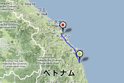
I ride north continuously today at National highway 1. Temperature lowered very much from HCMC. The red earth spreads out, but has a feeling that the transparency of the river increased.

Chien Dan, Hindu temple of the Champa kingdom. They were made in 11-12 centuries.

I rode 140km and arrived at Hoian. This was a tourist city.

 149.3 km / 1053.1km

view the broad map with a meters above the sea level graph
I rode through the mediocre way of the midland today.

On the roadside, the people made something.

And there was an amusement place of children.

Because my father goes for delivery, I tend the store while studying.

Good "nha nghi", dainty "com" and nice "caphe sua"

111.0 km / 903.8km

view the broad map with a meters above the sea level graph
National highway 1D, open cut new road.

Across a small mountain pass to provincial capital of Binh Dinh, Qui Nhon.

Slip on a rail track on road, for the first and only time in this trip.

In the hotel, I was with Russian motorcyclists. They were the tourists who took an animation.

 81.2 km / 792.8km

view the broad map with a meters above the sea level graph
Dai Lanh fishing port at dawn. There was no breakwater here. Fishermen passed on a pail boat.

I cycled heading north on National highway No.1. It was another 1185km to Hanoi.

In a bicycle shop, I oiled a chain. However, it was too thick.

95.5 km / 711.6km

view the broad map with a meters above the sea level graph
A color of the Ninh Hoa Station was a darkish yellow peculiar to Vietnam.

I pedaled a narrow way road in the small village. Village people enjoyed a cockfight by the roadside.

At the sandbar of Hon Gon, I struggled against a strong wind and a sand stone.

I arrived at the fishing village called Xom Con, and a chicken came out in the local restaurant where I sat to eat a fish.

 87.4 km / 616.1km

view the broad map with a meters above the sea level graph
I cycled on the Cam Ranh Peninsula around a bay. This was the last port of the Russian Baltic Fleet in 1905. After US Navy base, the Soviet Union fleet was stationed there.


Nha Trang iss the most famous beach resort in Vietnam, where large, foreign-affiliated, hotels were built.

 81.4 km / 528.7km

view the broad map with a meters above the sea level graph
I cycled to Cam Ranh Bay on national highway 27B today.
There were few place names on the map, and it was the quiet way, large cars were not to be seen.

A long elevated bridge led toa rice field. What is it?

The children of the village led me there. It was a waterway, not a elevated road.

Across the gentle hills, I was cycling leisurely.

I approached the sea, and merged with National Highway 1. I got my dirty bicycle professionally-cleaned in a motorcycle shop.

 71.7km / 447.3km

view the broad map with a meters above the sea level graph
I cycled along the sightseeing railroad from Da Lat to Tan Son today.
Because there are only five runs a day, grass grows on the railroad surface, but the bricks remain in the garage yard.

The city is surrounded by terraced fields which opene up to a gentle slope.

Trai Mat Station.

The downhill from the mountain pass was ...
The way performed extension works and was an approximately dirt way.

An old part of the National Highway 1, I felt the nostalgia of days gone by.

 78.4km / 375.6km


Japan Part for LABEL

Japan Part for LABEL

Powered by Lang-8 friends

boso.cycle@gmail.com


Taka
If you want to know the details, write a comment or send an email.

free counters