Showing posts with label "KHS F20-T2". Show all posts

view the broad map with a meters above the sea level graph

We pedaled in Okutama at the off-line meeting of the folding bike club.
Today was the first tour that I arranged. At 10:00 a.m. , five members gathered at Fujino Station.

We biked across the Tsuru mountain pass which was 870m in height, and rode over to Lake Okutama.

Because it was the holiday, during the height of the colored leaves season, many people were out riding road bikes.

Lake Okutama was at the upper reaches of the Tama River flowing through Tokyo. The railroad station is near, so we'll be there soon.

148.01 km。

view the broad map with a meters above the sea level graph

I pedaled in Kamakura at the off-line meeting of the folding bike club. At 10:00 a.m. , nine members gathered at Kita-Kamakura Station.

The first samurai Administration began in the 12th century in this city.
Because it is an ancient city near Tokyo, so many tourists were visiting there.

Beautiful origami paper cranes were dedicated at Zeniarai-benten.

Komyo-ji in Zaimokuza is the quiet temple which is a little far from the city center, but there is a well groomed garden.

Kamakura has various scenery in the undulating landscape.
I was able to go on cycling the way along the shore which opened out, the mountain path of a deep forest, and lively cityscape, at a time.

 40Km

Kudoyama and Koyasan

Aug 26, 2011

view the broad map with a meters above the sea level graph

I stayed in a Japanese hotel in Kudoyama-cho and cycled up to Mt. Koya-san. By chance, the Bon Festival was going on, and I could see farewell bonfires at Sanadaan in Kudoyama.

Kongohbuji temple is on Mt. Koya-san. It rises 750m from the foot of the mountain. This temple is the head temple of Shingon Buddhism.
Its burial ground is packed with the daimyo's graves from the Edo era.
When the property usage donation is not paid every year, the grave is destroyed, and the right to use it is sold to a different person.
This stable business model is lasting 400 years.

 100.03Km

view the broad map with a meters above the sea level graph

1300 years ago, the capital of Japan was Nara.
I cycled on the east hill of the Nara Basin today. This route is called "Yamanobeno michi".
There are many circular mounds, which exceed 250 meters in length. These mounds are surrounded by fields now.

The old forms of Shinto shrines remain. There is neither a sanctuary building nor an altar at Hibara Shrine. Christians interpret this as primitive culture but I think it is the spiritual essence of Japan.

Omiwa Shrine, Ichinomiya of Yamato country.

Because the way is narrow and there are many slopes and stone pavements, it is intended for mountain bikes.

 79.25Km

view the broad map with a meters above the sea level graph

It is cool and fine today. The temperature this morning will be 10 deg C.

I pedaled 17Km to the starting point for the climb, and walked up to the Mount Warning which was 1156m above sea level.

Because the mountaintop was sacred to the Aborigines, there were four lookouts around the summit.
I saw a double outer rim of a dead volcano.

I was able to saw down to Murwillumbah where I stayed.

When I came back to the town and did shopping, somebody called out to me. It was Cipollini whom I had ridden together with in Japan! We were going to meet at a hotel, but stumbled across each other.
I went to Chip and Lisa's house and I was served spaghetti with Italian cheese. Chip lived in Surfers Paradise, but, for the education of his children, moved to a country town last year.
33.73Km, 2h38m, 12.7Km/h , 4h for climb

view the broad map with a meters above the sea level graph

I rode heading north along the shore from Ballina today.

I arrived at Byron Bay via Lennox Head in the early afternoon. The Byron Bay station, which was used until 2004, became CountryLink(Train and bus company) travel center. Even now, the railway tracks are left.

I rode a bit inland and got on Pacific highway (Route 1) from the interchange. When a sense of Japan; there was an expressway.

I went down the interchange and made a turn into Tweed Valley Way. There was an old wooden railway bridge. It was only seven years ago that it became the abolished line.

Across some hills, I arrived at Murwillumbah in the Tweed River midstream. It is a fantastic beautiful town.
92.77Km,5h56m,15.5Km/h

view the broad map with a meters above the sea level graph

I moved by train from Brisbane to Casino.

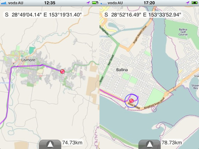
It was for the good of the real experience of the Cougal Spiral. The spiral line is not unusual, but without tunnel section is rare.

At Casino Station, I unfolded the bike and began cycling. The route to Ballina, it is 60km.

I saw road signs which alerted for koalas and kangaroos many times.

Ballina, located in the river mouth of the Richmond River, was a quiet town.
I used DIY GPS on the iPhone. This software does not need traffic of maps data. It was helpful for the cycling in the foreign country.(a montage of images)

66.73Km,4h02m,16.4Km/h

view the broad map with a meters above the sea level graph

Brisbane has the population of 2 million and is the third most populous city in Australia. The Brisbane River winds through the city.
The bike roads was made on the both sides of the river. In the center of city, without the embankment, the long viaduct on the river.

Brisbane had many slopes. There was a steep slope of 25% in the suburbs.

I cycled up Mount Coot-tha. It offers a superb outlook over the green city.

39.04Km,3h11m,12.2Km/h

view the broad map with a meters above the sea level graph

Today I cycled Mount Tamborine, which is 30km northwest of Surfer's Paradise. I joined Trevor, whom I had ridden together with from Yokohama to Enoshima in Japan.

We ate breakfast at Rob and Sue's house. There was a fixed cycling roller with a monitor at the garage. We had a superb view of the mountains on the wood deck.

I rode behind Peter on the plateau and enjoyed a downhill to Camungra, and many wineries were dotted along the way in the forest.
After that we moved to Brisbane by car, and pedaled along the river with Gus. The house of Mago was a sylvan quiet house.

48.37Km,3h19m,14.5Km/h

view the broad map with a meters above the sea level graph

My impression of Australia was beaches and desert, so I felt it would be unsuitable for cycling. However, the Australian cyclist Gus, whom I met at the Misaka Pass in last year, said "There are green mountains and the huge caldera !", so I decided to go.
I arrived at Coolangatta Airport in the south of the Gold Coast at 6:30. Gus pedaled in the rain and arrived at 9:30, just as promised.

This is the dry season, so rain is very rare. I rode behind Gus all day and lodged in his home at night.The rain eased off. At first we rode on the cycling road along the beach.
Because I carried a bike-packing bag on the steering bar and three sets of clothes on my back, I was heavy-armed for cycling.
The Gold Coast is appropriate to ride around by bike. It became clear in the evening.

A secret base of Gus's house.

The per person GDP in Australia is 10% higher than in Japan, but it is a big difference of the richness that added value brought in a garage, does not appear in the statistics.

63.62Km,3h55m,16.1Km/h


Japan Part for LABEL

Japan Part for LABEL

Powered by Lang-8 friends

boso.cycle@gmail.com


Taka
If you want to know the details, write a comment or send an email.

free counters