 view the big map with a meters above the sea level graph
 view the big map with a meters above the sea level graph
I was invited by a friend of the Chuetsu earthquake disaster revival planning aid to participate in a harvest rice volunteer. There is a base here which moniters for of the revival activity of the Niigata Chuetsu earthquake, which happened on October 23, 2004. I set up my bicycle at Odiya Station, and cycled to the accommodations in the mountain. This building is an old farmhouse. I set up my bicycle at Odiya Station, and cycled to the accommodations in the mountain. This building is an old farmhouse.My friend "M" is lives and does his work in the same house. He was an authorized architect of Tokyo, but he has moved. I am slightly anxious about his life. |
During the earthquake, a river was dammed up in a landslide and a natural dam was created. In those days, the government tore down an elementary school to avoid the collapse of the dam and made a waterway. The dam is left now.  |
I have the Japanese entry of the Taiwan bicycle touring in February 2009.
Now I asked my friend from Lang-8 to translate it to Chinese.
 I asked my friend to translate the diary of the third day, when I cycled south from Karen on the East Coast through the mountains. I asked my friend to translate the diary of the third day, when I cycled south from Karen on the East Coast through the mountains.(The diary of the original) I took a break at the "mountain spring water", near the flower examination laboratory. I filled up my water bottle. |
| (The reply from the Taiwanese friend) > When I read the diary of the third day, I was a little surprised. > taka drank water where the notice board said "山泉水請勿飲用". > This meaning is "Don't drink this water". > Taiwanese spring water is delicious but it's dangerous to drink without > boiling. Please be careful. I had understood "Please drink the water of the spring of the mountain", and drank in large quantities (LOL) But I was cheerful :-) Both Japanese and Chinese use kanji. However, jumping to a hasty conclusion is dangerous. |
 "Korea"
(9) Korea set meal
I forgot a name of meal.
A fish, pork, an omelet, vegetables etc.
(10) A rice porridge with abalones
"China"
(11) A roasted beef and a fried fish
"Thailand"
(12) A rice with chicken and vegetables
A meal in the outside(park or roadside) "Japan"
(13) A vinegared rice rolled in dried laver
(14) A bonito meal and loquats
(15) Croquettes
"Tawan"
(16) A canned food of a roasted eel
In a mountain on Zui-Kou road
 view the big map with a meters above the sea level graph
 "Japan"
(1)Thick white noodles in a wooden tub.
Thick white noodles = "udon"
*Usually we eat udon from a ceramic bowl.
(2)French-style Western food.
(3)Soba and a pork cutlet served on top of a bowl of rice.
*Soba is a type of thin Japanese noodle made from buckwheat flour.
(4)Chinese-style dumplings. "Taiwan"
(5)A smorgasbord of Chinese food and Western food.
(6)The Ikegami lunch in Taito station.
"Vietnam"
(7)Pho with beef.
*Pho is a Vietnamese common fast food, rice noodles.
(8)French bread.
There are a lot of shops that sell French bread in Vietnam.
 view the big map with a meters above the sea level graph
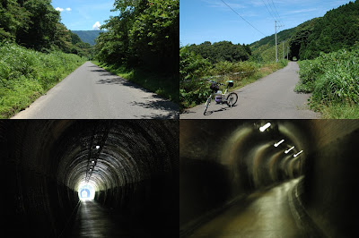
 The railroad which linked Kyoto to Kanazawa and Fukui has taken another route.
When the Hokuriku-Honsen-Railroad was inaugurated in 1896, the Japanese engineering works did not have the technology to dig a long tunnel, so they avoided the mountains and connected a route along the seashore by 12 short tunnels and four switchbacks. This place was a transportation bottleneck.
The Hokuriku tunnel, inaugurated in 1962, was the longest tunnel in Japan, with a total length is 13,870m.
After the tunnel opened, the old pike(railroad line) was converted into a road. Because the road is narrow, it is rarely used by cars. It is suitable for bicycles, but we must cycle with care because the old tunnels are gloomy and winding.
The ruins of the Suitsu station became the Suitsu rest stop on Hokuriku Expressway.
I left my bicycle behind the rest stop and entered the restaurant. Except me, there are drivers.
79.53Km
 I went to the Diet Library by bicycle.
The roads in Tokyo are crowded on weekdays, but not on Sunday. I followed Aoyama Street through Shibuya.
I dropped in on the Imperial Palace. In the Edo era (1603-1868), the shogunate lived here.
The reason that I went to the Diet Library was to copy old maps. Lots of maps surveyed and published more than 100 years ago are kept here.
I can see the changes of the city and the topography "volcanic activity and river repair", when I compare current maps with old maps.


