view the broad map with a meters above the sea level graph

I pedaled in Setagaya, which was a residential area of Tokyo.
Shoin Shrine was a Shinto shrine to honor Shoin Yoshida. After the Meiji Restoration, pupils of Yoshida constructed this shrine. Here were graves of Shoin Yoshida and Mikisaburo Rai, who died from penalty by the Mass Execution of Ansei. The Mass Execution of Ansei was political oppression by chief ministry Naosuke Ii of the Edo Shogunate.

Graves of the Ii's family were in the west, across the Setagaya ward office from Shoin Shrine. Here was a grave of Naosuke Ii. He was killed in the Sakurada-mongai assassination.
These events happened 150 years ago.

32.12Km

Jun 12 Coolangatta - Paradise Point /64km
Jun 13 Mount Tamborine, Brisbane /48km
Jun 14 Brisbane Mount Coot-tha /39km
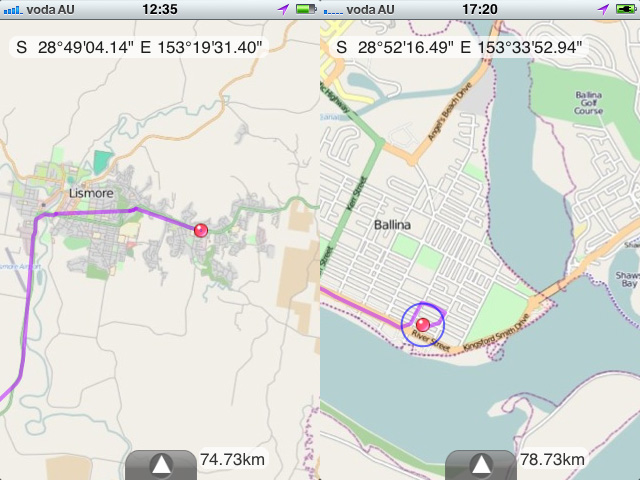
Jun 15 Brisbane (train) Casino - Ballina /67km
Jun 16 Ballina - Byron Bay - Murwillumbah /93km
Jun 17 walk up Mount Warning /34km
Jun 18 around Mount Warning /70km
Jun 19 Murwillumbah - Coolangatta /55km
Jun 20 Coolangatta - Tweed Heads /12km
Total 482Km

I stayed for three days in this town .

view the broad map with a meters above the sea level graph

It is cool and fine today. The temperature this morning will be 10 deg C.

I pedaled 17Km to the starting point for the climb, and walked up to the Mount Warning which was 1156m above sea level.

Because the mountaintop was sacred to the Aborigines, there were four lookouts around the summit.
I saw a double outer rim of a dead volcano.

I was able to saw down to Murwillumbah where I stayed.

When I came back to the town and did shopping, somebody called out to me. It was Cipollini whom I had ridden together with in Japan! We were going to meet at a hotel, but stumbled across each other.
I went to Chip and Lisa's house and I was served spaghetti with Italian cheese. Chip lived in Surfers Paradise, but, for the education of his children, moved to a country town last year.
33.73Km, 2h38m, 12.7Km/h , 4h for climb

view the broad map with a meters above the sea level graph

I rode heading north along the shore from Ballina today.

I arrived at Byron Bay via Lennox Head in the early afternoon. The Byron Bay station, which was used until 2004, became CountryLink(Train and bus company) travel center. Even now, the railway tracks are left.

I rode a bit inland and got on Pacific highway (Route 1) from the interchange. When a sense of Japan; there was an expressway.

I went down the interchange and made a turn into Tweed Valley Way. There was an old wooden railway bridge. It was only seven years ago that it became the abolished line.

Across some hills, I arrived at Murwillumbah in the Tweed River midstream. It is a fantastic beautiful town.
92.77Km,5h56m,15.5Km/h

view the broad map with a meters above the sea level graph

I moved by train from Brisbane to Casino.

It was for the good of the real experience of the Cougal Spiral. The spiral line is not unusual, but without tunnel section is rare.

At Casino Station, I unfolded the bike and began cycling. The route to Ballina, it is 60km.

I saw road signs which alerted for koalas and kangaroos many times.

Ballina, located in the river mouth of the Richmond River, was a quiet town.
I used DIY GPS on the iPhone. This software does not need traffic of maps data. It was helpful for the cycling in the foreign country.(a montage of images)

66.73Km,4h02m,16.4Km/h

view the broad map with a meters above the sea level graph

Brisbane has the population of 2 million and is the third most populous city in Australia. The Brisbane River winds through the city.
The bike roads was made on the both sides of the river. In the center of city, without the embankment, the long viaduct on the river.

Brisbane had many slopes. There was a steep slope of 25% in the suburbs.

I cycled up Mount Coot-tha. It offers a superb outlook over the green city.

39.04Km,3h11m,12.2Km/h


Japan Part for LABEL

Japan Part for LABEL

Powered by Lang-8 friends

boso.cycle@gmail.com


Taka
If you want to know the details, write a comment or send an email.

free counters