view the broad map with a meters above the sea level graph
I cycled to Cam Ranh Bay on national highway 27B today.
There were few place names on the map, and it was the quiet way, large cars were not to be seen.

A long elevated bridge led toa rice field. What is it?

The children of the village led me there. It was a waterway, not a elevated road.

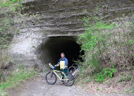
Across the gentle hills, I was cycling leisurely.

I approached the sea, and merged with National Highway 1. I got my dirty bicycle professionally-cleaned in a motorcycle shop.

 71.7km / 447.3km

view the broad map with a meters above the sea level graph
I cycled along the sightseeing railroad from Da Lat to Tan Son today.
Because there are only five runs a day, grass grows on the railroad surface, but the bricks remain in the garage yard.

The city is surrounded by terraced fields which opene up to a gentle slope.

Trai Mat Station.

The downhill from the mountain pass was ...
The way performed extension works and was an approximately dirt way.

An old part of the National Highway 1, I felt the nostalgia of days gone by.

 78.4km / 375.6km


Japan Part for LABEL

Japan Part for LABEL

Powered by Lang-8 friends

boso.cycle@gmail.com


Taka
If you want to know the details, write a comment or send an email.

free counters