
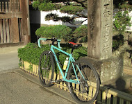
 For a feasibility study of The Map Trip Society, I went to Koga in Ibaraki.
This map is on a scale one to 20000 surveyed in 1885.
In this neighborhood, the topography changed after the river was repaired at the end of the Meiji period.
Koga was a castle town, but the castle was in low land and assumed Watarase River a moat.
The site of castle became a dyke and is a riverbed now, and there is on trace of it.
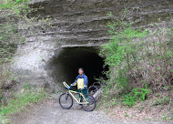
I walked Ibaraki,Saitama,Gunma and Tochigi today.
It is the spot of the prefectual border here, and I can trace into 4 prefectures by walking only 6 km.
(Watarase flood prevention area of the dusk)
 My road bicycle, Katakura Silk,was is very old. I don't ride at all. I wanted to know bicycles, so I went to a cycle-shop, TOKU, for the test ride.
  Because the size fits it me , it is TREK madone Pro 6.9 to have chosen.
This is very expensive.
An impression after the test ride:This is "another vehicle".
I can certainly run at high speed.
I feel the slope of 5% to 2-3%. The ride is comfortable, and the handling is easy.
I thought that even though my worldly desires were gone, I couldn't help but fall in love with this bike.
 view a big map with a meters above the sea level graph
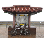
In Tokushima, Mt.Bizan to be equivalent to Mt.Kanouzan in the Boso Peninsula. There is the hill climbing course that is near from the city.
The water service building of the bake bricks was left in Sako. It was built for Taisho period.
18.3Km。
 Jun,2009. Jun,2009.I went to Ayutthaya by Ntional Railway from Bangkok and went around the temples of the world heritage site. |
 The rent-a-bicycle which I hired was a single speed and two seater. There were ruins which we could ride up by bicycle. |
 The instructions for the pagoda were only Japanese. The instructions for the pagoda were only Japanese. |
 |
 12/19 41.3Km in Hanoi city
12/20 101.6Km Mt.TamDao (960m)
12/21 Halong Bay Bus Tour
12/22 105.4Km LuongSon
12/23 124.7Km KimBoi via HoaBinh
12/24 80.1Km KimBoi -> Baichao -> Bailang -> Hanoi
12/25 50.3Km HoTay -> YenVien -> LongBien -> Hanoi Bicycle Club Christmas party in Ushiwakamaru
12/26 193.4Km LangSon -> (border) -> PingXiang(China)
12/27 69.5Km PingXiang -> (border) -> LangSon
TOTAL 767.5Km


